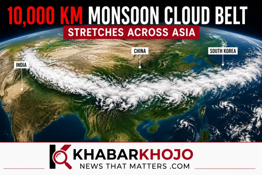
Satellite view of a massive monsoon cloud belt extending across Asia, highlighting weather activity from India toward South Korea.
A Massive Cloud Formation Has Caught Global Attention
A giant weather system stretching thousands of kilometres across Asia has become one of the most talked-about weather developments of the week. Satellite images released by meteorological agencies show a continuous 10,000 km monsoon cloud belt extending from parts of the Indian subcontinent toward East Asia, including regions near South Korea.
The images quickly spread across social media, where many users described the formation as a “wall of clouds.” While the phrase sounds dramatic, weather experts explain that it is not a literal wall. Instead, it is a long band of moisture-rich monsoon clouds that developed under favourable atmospheric conditions.
Scientists say such large cloud formations are linked to seasonal monsoon circulation and can significantly influence rainfall across several countries at the same time.
What Exactly Is the 10,000 Km Monsoon Cloud Belt?
The 10,000 km monsoon cloud belt is a broad zone of thick rain-bearing clouds connected through the seasonal monsoon system. It forms when warm, moisture-filled air rises and interacts with changing wind patterns across Asia.
Unlike a cyclone or hurricane, this cloud belt does not rotate around a single centre. Instead, it stretches across multiple countries, carrying enormous amounts of water vapour through the atmosphere.
Meteorologists often observe similar cloud bands during active monsoon periods, but this week’s formation attracted attention because of its exceptional length and the impressive satellite imagery showing its continuous structure.
Where Was This Massive Cloud Belt Seen?
According to satellite observations, the cloud band extended across several parts of Asia. It covered regions of India before stretching toward the Himalayan region, parts of China, and areas closer to the Korean Peninsula.
Although headlines suggested that South Korea had a giant cloud wall above it, the weather system actually covered a much larger geographical area. Different sections of the cloud belt affected different countries in different ways depending on local weather conditions.
Experts explain that every location under the cloud band may not receive heavy rainfall at the same time. Rainfall depends on temperature, humidity, wind direction, and local atmospheric instability.
Why Did This Weather System Form?
Weather specialists believe several natural atmospheric conditions combined to create this unusually long cloud formation.
One of the biggest reasons is the strong summer monsoon circulating across Asia. During this season, warm oceans continuously supply moisture into the atmosphere. As this moist air moves inland and collides with cooler air masses, thick cloud systems begin to develop.
Upper-level winds also help organise these clouds into long, connected bands. When favourable wind patterns remain stable for several days, the cloud formation can stretch across thousands of kilometres.
This process is completely natural and is observed during active monsoon periods, although formations of this scale attract much greater public attention.
Why Are Satellite Images Going Viral?
Modern weather satellites provide extremely detailed images of Earth’s atmosphere. In this case, the satellite view displayed an almost continuous band of clouds stretching across a large portion of Asia.
Because the cloud band appeared unusually long from space, many people compared it to a giant white wall surrounding multiple countries.
However, meteorologists caution that satellite images often create visual impressions that can be misunderstood without scientific explanation. What appears to be a single solid cloud is actually a collection of connected rain clouds developing under the same weather system.
This is why experts prefer using terms such as monsoon cloud band or monsoon cloud belt instead of “cloud wall.”
Could It Bring Heavy Rainfall?
Yes, weather experts believe this large-scale weather system has the potential to increase rainfall activity in several regions.
Areas already experiencing active monsoon conditions may continue receiving moderate to heavy rain depending on local atmospheric factors. In mountainous regions, prolonged rainfall can increase the risk of landslides, while low-lying areas may face waterlogging or flash flooding if rain continues for several days.
Authorities in different countries continuously monitor satellite observations and weather models to issue rainfall alerts whenever necessary.
Although the cloud belt itself does not automatically guarantee severe weather everywhere, it indicates that the atmosphere contains a significant amount of moisture capable of producing widespread rain under suitable conditions.
Is This a Rare Weather Event?
The recent cloud formation has attracted worldwide attention because of its remarkable size. However, weather experts explain that long cloud bands are a natural part of the Asian summer monsoon. What makes this event stand out is the impressive satellite imagery showing the cloud system stretching across several countries at the same time.
Meteorologists note that these large cloud belts develop when moisture, wind patterns, and atmospheric pressure align over a vast region. Such conditions do not occur every week, which is why this event has become a major topic in weather discussions.
It is also important to understand that a large cloud belt does not mean every city beneath it will experience heavy rain. Local weather conditions, topography, and temperature differences determine where intense rainfall actually occurs.
Are Climate Change and Global Warming Responsible?
Scientists are still studying the exact influence of climate change on individual weather systems. However, many climate experts agree that a warmer atmosphere can hold more moisture than before. This increases the possibility of heavier rainfall during active monsoon periods.
Climate change does not create monsoons, but it can influence their intensity and rainfall distribution. In recent years, several Asian countries have witnessed stronger downpours, flash floods, and extreme weather events linked to changing climate patterns.
Researchers continue to monitor long-term weather data to better understand how rising global temperatures affect monsoon behaviour across Asia.
Why Accurate Weather Reporting Matters
Satellite images often spread quickly across social media, but they do not always tell the complete story. A dramatic image can easily be misunderstood without scientific context.
Many online posts described the formation as a “10,000 km cloud wall.” While the image looks spectacular from space, meteorologists explain that it is more accurate to call it a monsoon cloud belt or rain-bearing cloud band.
Understanding the science behind such events helps readers avoid misinformation and better prepare for genuine weather risks.
What Should People Do?
People living in regions expecting heavy rainfall should continue following updates issued by their local weather authorities.
Some useful precautions include:
- Keep track of official weather forecasts.
- Avoid travelling through flood-prone roads during heavy rain.
- Charge essential electronic devices before severe weather.
- Stay away from overflowing rivers and landslide-prone areas.
- Follow evacuation instructions if local authorities issue alerts.
Preparation based on official forecasts is always more reliable than relying on viral social media posts.
Final Thoughts
The 10,000 km monsoon cloud belt has become one of the most talked-about weather developments because of its extraordinary appearance in satellite images. Although many people referred to it as a giant “cloud wall,” scientists clarify that it is a naturally occurring monsoon cloud band stretching across a large part of Asia.
The event highlights the scale of Earth’s weather systems and the importance of accurate scientific reporting. While the cloud belt may contribute to rainfall across several countries, its effects vary from one region to another.
As weather agencies continue monitoring the situation, people are encouraged to stay informed through trusted meteorological updates rather than relying solely on viral posts.
Frequently Asked Questions (FAQ)
What is the 10,000 km monsoon cloud belt?
It is a long band of moisture-rich monsoon clouds visible in satellite images, stretching across several parts of Asia.
Is it really a cloud wall?
No. “Cloud wall” is a media-friendly description. Weather experts refer to it as a monsoon cloud belt or cloud band.
Which countries are affected?
The cloud system has been observed across parts of India, the Himalayan region, China, and areas extending toward the Korean Peninsula. Weather impacts vary by location.
Does this mean heavy rainfall everywhere?
No. Rainfall depends on local atmospheric conditions. Some areas may receive heavy rain while others experience only cloud cover.
Is this connected to climate change?
Scientists say climate change can increase atmospheric moisture and influence rainfall intensity, but it is not the sole reason such cloud belts form.
.
📲 Follow Khabar Khojo for the latest weather updates and breaking news.
Instagram: @officialkhabarkhojo https://instagr.am/officialkhabarkhojo
Read our latest Global News updates for more international stories; https://khabarkhojo.com/global-news/
Sources
- India Today Science – Satellite images aur cloud belt ki report.
- India Meteorological Department (IMD) – Official monsoon updates.
- World Meteorological Organization (WMO) – Global weather and climate information.
- NOAA Satellite and Information Service
- EUMETSAT (European Weather Satellite Agency)



More Stories
Trump’s New Tariffs 2026: US Imposes Fresh Import Duties on 60 Countries, Global Trade Faces New Uncertainty
India News July 2026: Top Updates From the Last 24 Hours Amid Chaos, Plus Kashmir Security Update
Ahmedabad Weather News Today: 24-Hour Red Alert Triggers Severe Flood Chaos